

What are the environmental characteristics of Satoyama land?
Rice paddies, vegetable fields, forest and river, wild boars and deer…it is difficult to make succinct explanation.
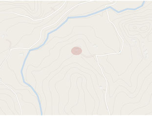
I cannot make academic analysis but I would like to try to explain the terrain profile of Satoyama using a map today.
Red circle is where our Kominka old house is located. It is in the hills of Mineoka Mountains in Southern Boso area, Chiba Pref.
Dark green shows forest, white line shows road, what looks like a dot is a house or a building.
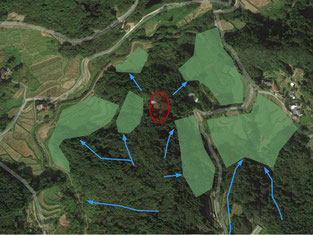
Map with contour line shows more clearly the shape of mountain and river. You can see that the Kominka old house is on the flatland halfway up the mountain. With contour lines, we can see that Satoyama land consists of varieties of small valleys, slopes, flat areas and hills. I can read valleys with the width and lines of contour, and put blue lines as shown below.

Our Satoyama land has many (small) uphills and downhills and surrounded by valleys. Where there used to be rice terrace as boxed with line are on the valleys from the top of the mountains. That is why the small areas are wetter after rain than other areas in the land.
Then the valleys run down to east and west, divided around the Kominka old house area.

People who used to live in the area created rice fields, apparently utilizing the water that runs through the valley. It is easy to notice by spotting valleys and rice fields on the contour map.
Rice paddies in the area have no water irrigation system and rely merely on rain water, so people wouldn’t have been able to cultivate the land successfully without understanding the terrain characteristics of the land.
The beautiful traditional Japanese scenery are designed and created by our ancestors, our forerunners. I am always amazed how deeply and wisely these people read the land and the nature.
Now some of the rice paddies are abandoned. Maybe we can say they are now “valleys not functioning.” In Satoyama DIY, the importance of valleys cannot be emphasized more, since flows of water and air are converged on valleys on and under the ground.
I made my Satoyama DIY plan looking into the map carefully and carried out the work.
My current sub-project (Forest DIY---Working on Water) is also planned out with the map.
I would like to reenergize Satoyama land by cleaning the valley and digging various holes in the ground to regain the flows of water and air. That is the basis of my Satoyama DIY.
Using maps and following ancestors’ footsteps give me deeper understanding of the environment and nature of Satoyama land, which leads to gaining wisdom to live in the nature.
It also makes me realize that not working on the land day to day but taking some time to sit back and gain holistic view of the land on the desk is also important.
“Missing the forest for the trees”
The idiom gives me lots of wisdom for my Satoyama DIY.